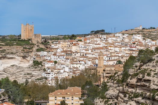
Nestled among the rolling hills and sun-soaked plateaus of Castilla-La Mancha, Canalejas del Arroyo is a hidden gem for hikers seeking authentic Spanish countryside experiences. While the village itself is steeped in history and rural charm, its surrounding landscapes offer a surprisingly diverse array of trails for adventurers of all skill levels. Whether you’re a seasoned trekker craving a challenge or a casual walker in search of breathtaking vistas, the area around Canalejas del Arroyo promises unforgettable hikes that blend natural beauty with cultural richness. This guide explores the best hiking trails around Canalejas del Arroyo, offering in-depth trail descriptions, practical tips, and a comparative overview to help you plan your next outdoor escape.
The Landscape Around Canalejas del Arroyo: A Hiker’s Dream
The region surrounding Canalejas del Arroyo is defined by its unique geography. Located in the province of Cuenca, it sits at an elevation of approximately 974 meters (3,195 feet), providing sweeping views of the surrounding valleys and sierras. The terrain is a patchwork of pine forests, limestone outcrops, fertile fields, and meandering streams. This diversity translates directly into a variety of hiking environments—from shady woodland paths to exposed ridgelines with panoramic vistas.
What sets this area apart for hikers is its accessibility. Unlike some of Spain’s more famous hiking destinations, the trails near Canalejas del Arroyo are rarely crowded. This means you can experience the tranquility of nature without the bustle of tourist hotspots. Additionally, the region’s moderate Mediterranean climate—average summer highs of 28°C (82°F) and mild winters—makes it possible to enjoy hiking nearly year-round.
.png)
Top 5 Hiking Trails Near Canalejas del Arroyo
While there are dozens of footpaths and rural tracks weaving through the countryside, these five trails stand out for their scenery, accessibility, and unique features:
1. $1 - Distance: 12 km (7.5 miles) loop - Difficulty: Moderate - Highlights: Dramatic limestone cliffs, seasonal waterfalls, and rich birdlife 2. $1 - Distance: 8 km (5 miles) out-and-back - Difficulty: Easy to Moderate - Highlights: Panoramic views of the Serranía de Cuenca, wildflowers in spring, ancient shepherd huts 3. $1 - Distance: 14 km (8.7 miles) loop - Difficulty: Moderate to Challenging - Highlights: Natural springs, traditional stone fountains, picnic spots 4. $1 - Distance: 6.5 km (4 miles) loop - Difficulty: Easy - Highlights: Riverside walking, chance to spot otters, family-friendly 5. $1 - Distance: 9 km (5.6 miles) round-trip - Difficulty: Moderate - Highlights: Summit viewpoint, 360-degree landscape photography opportunitiesEach trail offers a distinct hiking experience, from leisurely riverside strolls to rewarding climbs with sweeping views. Below, we’ll dive deeper into what makes each one special.
In-Depth Look: Sendero del Barranco de la Hoz
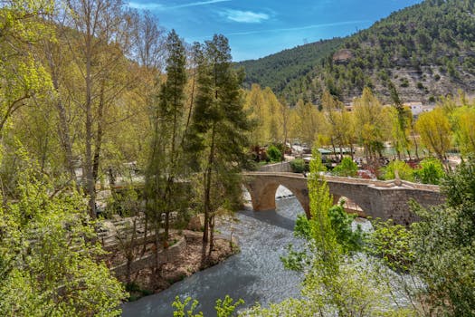
The Sendero del Barranco de la Hoz is a must-hike for anyone visiting Canalejas del Arroyo. This loop trail takes you through one of the region’s most dramatic natural features—a gorge carved by centuries of water erosion. The path meanders along the edge of limestone cliffs rising over 40 meters (131 feet) above the valley floor, offering adrenaline-pumping viewpoints and the chance to spot griffon vultures soaring overhead.
Spring and early summer are the best seasons for this trail, when the usually dry riverbed fills with water, creating picturesque waterfalls and lush pockets of wildflowers. The hike is rated moderate due to some rocky sections and gentle elevation gain, making it accessible to most hikers with reasonable fitness. Birdwatchers will especially appreciate the diversity here, with over 50 species recorded, including golden eagles and Eurasian hoopoes.
Discovering the Natural Springs: Camino de las Fuentes
If you’re drawn to the gentle sound of flowing water, the Camino de las Fuentes is the trail for you. Translating to “Path of the Springs,” this 14-kilometer loop explores the life-giving sources that have sustained Canalejas del Arroyo for centuries. The route connects several historic stone fountains, many constructed during the 18th and 19th centuries and still in use today.
The path winds through sun-dappled pine forests and crosses open meadows where locals have grazed livestock for generations. Several stretches are perfect for a picnic, particularly around the Fuente del Tío Paco, a shaded spot with cool, drinkable water. While the trail is mostly gentle, a few steeper segments provide a moderate challenge, especially after rain. The blend of cultural history and natural beauty makes this route a favorite among locals and visitors alike.
Wildlife Encounters on Vereda del Río Mayor
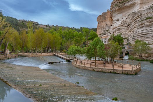
For families and those seeking a shorter, easier walk, Vereda del Río Mayor offers a delightful riverside experience. This 6.5-kilometer loop hugs the banks of the Río Mayor, a clean and lively stream that supports a surprising array of wildlife. Keep your eyes peeled for otters—often seen at dawn and dusk—as well as kingfishers darting along the water.
Interpretive signs along the way provide insights into the area’s ecology and the importance of healthy waterways. With minimal elevation change and mostly shaded path, this trail is ideal for children or anyone looking for a relaxing stroll. Several access points allow you to dip your feet in the river or enjoy a packed lunch on the bank.
Summit Views: Ruta del Mirador de la Muela
Those seeking more challenging terrain and jaw-dropping views should head for the Ruta del Mirador de la Muela. This 9-kilometer round-trip trail climbs steadily to the Mirador de la Muela, a natural viewpoint perched atop a limestone mesa. At 1,120 meters (3,674 feet) above sea level, the summit offers 360-degree views over the valleys, forests, and distant peaks of the Serranía de Cuenca.
Photographers and nature lovers flock here for sunrise and sunset, when the landscape glows with golden light. The climb is steady but manageable, with switchbacks and several rest spots. On clear days, you can see as far as the city of Cuenca, nearly 40 kilometers (25 miles) to the southeast. The area is also notable for its spring wildflowers and occasional sightings of ibex.
Comparative Overview: Trail Features and Stats
To help you choose the best hiking experience, here’s a side-by-side comparison of the top five trails near Canalejas del Arroyo:
| Trail Name | Distance (km) | Difficulty | Main Features | Best Season |
|---|---|---|---|---|
| Sendero del Barranco de la Hoz | 12 | Moderate | Limestone cliffs, waterfalls, birdlife | Spring, Early Summer |
| Ruta de la Sierra de Bascuñana | 8 | Easy-Moderate | Panoramic views, wildflowers, shepherd huts | Spring, Autumn |
| Camino de las Fuentes | 14 | Moderate-Challenging | Natural springs, historic fountains, picnic spots | Spring, Summer |
| Vereda del Río Mayor | 6.5 | Easy | Riverside walk, wildlife, family-friendly | Year-round |
| Ruta del Mirador de la Muela | 9 | Moderate | Summit views, photography, wildflowers | Spring, Autumn |
Planning Your Hiking Adventure: Tips and Essentials
Hiking in the Canalejas del Arroyo area is generally safe and enjoyable, but a little planning goes a long way. Here are some practical tips to make the most of your experience:
- $1 The best times for hiking are spring (April–June) and autumn (September–November), when temperatures are comfortable and the landscape is especially vibrant. Summer can be hot, particularly in exposed areas, so start early and bring plenty of water. - $1 While the region is free from dangerous large animals, you may encounter wild boar, foxes, or snakes. Always stay on marked trails, and avoid disturbing wildlife. - $1 Most main trails are marked with painted blazes or wooden signs, but carrying a map or GPS device is recommended, especially on longer routes. - $1 Canalejas del Arroyo offers basic services, including a grocery store, pharmacy, and several cafés. For more extensive supplies, the town of Cuenca (about 45 minutes by car) has all necessary amenities. - $1 Many trails pass through private farmland or grazing areas. Always close gates, avoid picking crops, and greet local farmers with a friendly “¡Buenos días!”Why Hiking Near Canalejas del Arroyo Is a Unique Spanish Experience
What makes hiking in this region so special is the interplay between natural beauty and living tradition. Trails often follow ancient routes once used by shepherds and traders, connecting you not just with the land but also with centuries of rural Spanish history. Encounters with local villagers, sightings of traditional stone huts, and the ever-present sound of distant church bells add layers of authenticity that are increasingly rare in today’s world.
Moreover, the area’s biodiversity—over 800 plant species and 70 recorded bird species—means every walk offers new discoveries. Whether you’re marveling at the spring wildflower display or quietly observing the riverbank at dawn, the trails around Canalejas del Arroyo invite you to slow down, breathe deeply, and immerse yourself in the rhythms of the Spanish countryside.